Places Mentioned in The Tory Lover
This list allows one to read through the locations mentioned in The Tory Lover. Nearly all locations in the novel have been established as actually existing places. In the list below, the numbers in parenthesis after the name indicate the chapters in which the place is mentioned. When a place is mentioned often, only the first appearance is indicated.
| A | B | C | D | E | F | G | H | I/J | K | L | M |
| N | O | P/Q | R | S | T | U/V | W | X/Z |
Agamenticus (and the Three Hills) (7): In Piscataqua Pioneers (2000) Sylvia Getchell says Agamenticus was the Indian name for the York River (11). In histories of Maine, the whole area that now comprises York County in Maine is sometimes called Agamenticus. The settlement area of Agamenticus was renamed Gorgeana when chartered in 1642 and then renamed York in 1652, when it was reorganized as a town. (See Maine: A Guide 'Down East,' 1937.) Mt. Agamenticus is about mid-way between South Berwick and Ogunquit. A little northeast of Mt. Agamenticus is Second Hill, and somewhat further in the same direction is Third Hill.
Alençon (21): On a route from Brest to Paris, Alençon is about 3/4 of the way. In the 18th-century the town was known for its lace and textiles.
Arbigland (6,22): The fishing hamlet where John Paul
Jones was born in the western lowlands of Scotland on the north
shore of Solway Firth near the present-day village of Kirkbean.
The village is across the firth from Whitehaven.
[ Top of Page ]
Badger Island (29): See Langdon's Island
the Banks (12): This could be Georges Banks, a fishing ground off the coast of Cape Cod in Massachusetts, or the Grand Banks, another fishing ground south of Newfoundland, Canada.
Bantry (3,17): On the southern coast of Ireland, on Bantry Bay.
Barvick (2 and several other chapters): See Berwick.
Basilica of St. Denis: See Paris.
Bath (34): East of Bristol, England, on the Lower Avon River. Graham Frater writes: "Modern roadmaps show that the city of Bath is some 13 miles to the south east from Bristol city centre. Bath was developed by the Romans for its hot springs; much of the eighteenth century city that Jane Austen described still survives (see: www.janeausten.co.uk), as do many Roman remains, including their baths. Jewett refers to no specific locations within Bath; this may argue that she did not visit the city, but her appreciative descriptions of the countryside on the journey to Bath do perhaps suggest first-hand observation; they certainly invoke the links between England and America that Jewett had emphasised in her conclusion to The Story of the Normans, and in her childrens novel with an English setting Betty Leicester's Christmas."
Beare (3 and others): The area of southern Ireland over which the O'Sullivan family (Master Sullivan's ancestors) ruled prior to the 17th century.
Beech Ridge (9): There is a Beech Ridge in DeLorme's The Maine Atlas (2001), about 2 miles west of York Village, and another, more likely to be the location Jewett refers to, northeast of Berwick, nearly half way to Sanford. This location along with Tow-wow/Lebanon would indicate the length of Colonel Hamilton's journey - more than 20 miles round trip - the day after the Ranger sails. It would be convenient for Hamilton to stop as expected for dinner with Master Sullivan at Pine Hill, though he does not on this day.
Belle Isle (18): In France; see Breton coast.
Berwick (1 and many other chapters): On the Salmon Falls
River in southern Maine, sometimes referred to as "Old Barvick."
Since 1814 the original Berwick has been divided into the three
neighboring towns: Berwick, North Berwick and South Berwick, the
home of the Hamiltons. South Berwick, Jewett's birthplace and
home, was the original settlement, and it is divided into
regions that have been centers of commerce during the town's
history.
These include (see Berwick map):
Upper Landing (28 and others): At the head of the tidewater, sometimes called Quamphegan, the last place at which boats could land going up river, just below Salmon Falls. Today this location remains a landing for small boats, and is the site of the Counting House Museum of the Old Berwick Historical Society, with exhibits open on weekends and by appointment, and with reference, document, and artifact collections for research in local and regional history.
Lower Landing (8,29): About one mile down river from the Upper Landing, in deeper water near Hamilton Brook, where Hamilton House is located. Also known in early settlement times as Pipe Stave Landing, because barrel staves, called pipe staves, were an important local export in the Caribbean trade.
Great Works (2): From the 17th through the 19th century, Great Works referred to a mill area -- first lumber, later wool processing -- on the Great Works River in South Berwick. This area along with Old Fields, was the earliest settled part of the town. During the 1770s, the village center was moving westward, to the location near Jewett's home, the house where Tilly Haggens is said to live in the novel. (See Tilly Haggens's House below).
Other South Berwick landmarks and locations in the novel:
Butler's hill (8): Tilly Haggens could see this hill on his left while sitting on the front porch of the Jewett house in November of 1777 at the beginning of Ch. 8. This is now known as Powderhouse Hill; it is the site of the Berwick Academy. Source: York County Atlas of 1872. The Butler family, in their genealogy at the Old Berwick Historical Society, believes the hill was named for Thomas Butler (b. 1674), who settled in Maine around 1695, and whose homestead was at the foot of this hill.
Tilly Haggens's House (8):
This house is now known as the Jewett House, where Sarah Orne
Jewett was born and where she lived after the death of her Uncle
William Jewett in 1887. Wendy Pirsig points out that the "broad
space" in front of the Haggens house was a watering place for
animals for many years -- a spring/cistern was below the street.
Jewett describes the front porch as having Corinthian columns,
but this seems to be an error. It is possible that Jewett did
not distinguish the styles of classical columns; in "The Old
Town of Berwick" she says the First Parish Church once had
Corinthian columns, but this church actually has relief
decorations representing Doric columns.
Whether the historical Tilly Haggens
actually built or lived in this house is a contested issue; see
Tilly Haggens on the list of People.
Old Fields (28,31): Everett S. Stackpole in "South Berwick: The First Permanent Settlement in Maine," locates Old Fields at the southern end of the current village of South Berwick. He says this was originally the location of the Spencer Garrison, built before 1675 a site associated with the northernmost limit of Old Fields Road, and with the Ichabod Goodwin house, 1 Old Fields Road. It includes the site of the Old Fields Cemetery, where several of the local historical characters of this novel are buried. Hamilton House stands on the river in the Old Fields area. See "The Old Town of Berwick" for a photograph.
The Old Vineyard (28,32): Everett S. Stackpole in "South Berwick: The First Permanent Settlement in Maine," locates the old vineyard just north of the mouth of the Great Works River in South Berwick. What remains of this area now faces Leighs Mill Pond on Vine Street in South Berwick.
Plaisted¹s Hill (8): Probably this is the site of a Plaisted farm on the road to Berwick about half a mile from Haggens house. In the 17th century, a Plaisted family owned one of the earliest farms along the Salmon Falls River, scene of an Indian raid in 1675. See Jewett's "The Old Town of Berwick" and also Hertel on the list of People.
Pound Hill/ Pound Hill Farms
(28): No map has been found identifying this area. Jewett says
that when the bringers of news from Portsmouth leave the Lower
Landing, "The messengers were impatient to go their ways among
the Old Fields farms, and went hurrying down toward the brook
and around the head of the cove, and up the hill again through
the oak pasture toward the houses at Pound Hill." This would
seem to place Pound Hill east of Hamilton House. Norma Keim of
the Old Berwick Historical Society has located the actual hill
on what is now Fife's Lane, which once was part of the main road
from Old Fields to York. This location is just east of Old
Fields. See The Maine Spencers, A History and Genealogy
by W. D. Spencer (Concord: Rumford Press, 1898) p. 108. It is
quite likely that the name derives from the location of the
village livestock pound. In the colonial period, many New
England villages had pounds where strayed livestock would be
kept at village expense until the owners claimed them and payed
their fine or pound fee. (See John R. Stilgoe, Common
Landscape of America 1580-1845. New Haven: Yale UP, 1982,
p. 49).
Bordeaux (23): A major fishing port in southwestern France.
Boston (2 and many others): in Massachusetts, a center of revolutionary activity.
Brest (21 and others): A major French port and naval base on the Penfeld River at the western end of the Breton peninsula. See Quiberon.
Breton coast (15 and others): The coast of Brittany in France. On a trip by sea from Nantes, a port in the mouth of the River Loire to Brest a port at the western tip of the Breton peninsula in France, one may sail along the southern coast of the peninsula. Paimbœuf and St. Nazaire are also in the mouth of the Loire, west of Nantes. Presqu'ile de Quiberon is a small peninsula about half way along this journey. Off the end of this peninsula is Belle Île (Belle Isle). Lorient (L'Orient) is a port west of Quiberon.
Bristol (2 and others): A major seaport in southwestern England, where the Lower Avon flows into the Severn and then into Bristol Channel. Research on the locations in the Bristol vicinity is by Graham Frater, who provides these acknowledgments: For help and guidance on gathering local evidence for the Bristol sections of the The Tory Lover, warm thanks are due to Mr John Penny of the Fishponds Historical Society (http://www.fishponds.freeuk.com/), Ms Madge Dresser of the University of the West of England, Mr and Mrs T. Ross [the owners of Old Passage House, Aust, formerly the Old Passage Inn), Ms Sheila Lang of the Bristol Records Office, Jan Wood, archivist of the Devon Records Office, Mr and Mrs R. Ebbs of Littleton-upon-Severn, Joy Coupe, Administrator at Bristol Cathedral.
The abbey church of St. Augustine
(38) in Bristol in the 18th Century would have been
what remained of the Abbey of St. Augustine. [ Photographs ]
The present Cathedral Church of the Holy and
Undivided Trinity was founded as St Augustine's Abbey in 1140.
The Chapter house and Abbey Gatehouse survive, as do several of
the side chapels, and the night stairs, but the uncompleted nave
was demolished when the abbey was dissolved in 1539. The
remaining portions of the abbey became the new cathedral (1542),
or formed parts of Bristol Cathedral School, next door. The
cathedral was further developed in the nineteenth century. See
also: www.bristol-cathedral.co.uk.
Since this was the site of the original
abbey, and since some of those original buildings remain,
including the gatehouse, (where Mary passed 'two forlorn
Royalists' just before she went in), it seems most likely that
this is the church referred to in the novel. However, there was
also a church of St Augustine the Less, of which Sheila Lang
writes: 'Before the creation of Bristol Diocese the Abbey of St
Augustine was a major landowner, situated in the city centre. At
the Dissolution of the monasteries by Henry VIII, all the lands
and property of the Abbey went towards the endowment of the new
Diocese of Bristol in 1542. Near the Cathedral stood the church
of St Augustine the Less in the 18th century. It was damaged in
the blitz, and demolished in the 1960s, and a hotel [the
Swallow] now occupies the site."
Before he was translated to St Paul's in
London, The Reverend Sydney Smith (1771-1845), whose biography
Kate and Helen mention as a favourite in the last chapter of
Jewett's Deephaven, was a prebendary canon of Bristol
Cathedral. He was a prominent reformer, and the founding editor
of the highly influential Edinburgh Review. He mischievously
preached a sermon on Catholic toleration to the burghers of
Bristol on 5th November 1828 (Nov 5th is commemorated to this
day with fireworks to celebrate Britain's 'salvation' from Guy
Fawkes's pro-Catholic Gunpowder Plot, 1605 -- intended to blow
up King and parliament).
Joy Coupe of the Bristol Cathedral points out that the
monument Mary views in Chapter 38 is the Newton monument in the
Newton Chapel. The parents shown died in 1599, so they
died in the reign of Elizabeth I, but the monument probably is
Jacobean. The parents, Ms Coupe points out, are lying down
rather than kneeling. The children are kneeling in the
height order described in the text.
Bristol Quay (33): Not a single quay, but a cluster of wharfs and quays in Bristol harbor, close to the city center. Sheila Lang writes: 'There are several quays within the city, as two rivers flow through the city centre, the Avon and the Frome. Broad Quay and Narrow Quay are still in existence, but the Quay itself is now known as Quay Street, and the river has been culverted in this area, so the Quay has gone; [the] reference to Bristol Quay could be to any of these." [ Photographs ]
Clifton Downs (32 and others): Clifton Downs is now a large public common, high above the city near to the University of Bristol, and Brunel's suspension bridge. The Downs still afford fine views of the city just as Davis suggests, and the Dundry Hills can be seen from there too. [ Photographs ]
Mr. Davis's house (33): The text suggests that this was close to the waterside, the wharves where the ships were unloaded, and the warehouses where their cargoes were stored. Bomb damage in World War II left few such merchants houses standing. If the house was indeed close to the quayside, it would have been only a short walk to Bristol Cathedral, (the Abbey Church of St Augustine).
Dundry (43): The Dundry Hills lie some six miles to the south of Bristol, and may be seen from several parts of the city, including Clifton Downs. [ Photographs ]
King or King's Road: King's Road: the stretch of water close to the village of Pill where the River Avon, (along which Bristol grew up), joins the Severn Estuary. From this point it was customary for the men of Pill to pilot ships into Bristol's wharves and docks (source: John Penny). Sheila Lang of the Bristol Record Office writes: "King Road and Hung Road are areas in the River Severn estuary, near to where the River Avon flows into the Severn from Bristol."
St. Mary Radcliffe (43): St. Mary Redcliffe (not Radcliffe) remains a sizeable and prosperous city church in Bristol. See also www.stmaryredcliffe.co.uk. [ Photographs ]
Butler's Hill: See Berwick.
[ Top of Page ]
Cambrai (17): An agricultural and industrial region, specializing in textiles in northern France, southwest of Lille, along the Escaut River. This is the town where Fénelon resided at his death, hence Master Sullivan's travels there with Fénelon's nephew, the Abbé de Beaumont: (Research assistance: Travis Feltman)
Cambridge (2): In Massachusetts, west of Boston, the location of Harvard College, now Harvard University.
Carrickfergus (27,31): In northeast Ireland, on the Belfast Lough, north of Belfast.
Carnac/Mont St. Michel (23): Carnac is a village near the Atlantic coast of Brittany (Bretagne) in northwestern France, famous for its prehistoric stone monuments known as menhirs and dolmens (sometimes associated with Druids), which seem to be linked historically to the nearby Mont St. Michel off the coast of Normandy. (Research: Travis Feltman; Source Encyclopedia Britannica Online)
Carsethorn Bay (2,6): The port town of Carsethorn in Scotland is down river from Dumfries on the River Nith, near J. P. Jones's birthplace at Arbigland.
Channel (12 and others): The English Channel, between England and France.
Chippenham (43,44): A town east of Bristol, in England.
Christian Shore (10): Now in northwest Portsmouth, N.H., across from the western part of Kittery, on the Piscataqua River.
Clifton Downs: see Bristol.
Collége Louis-le-Grand (17): A prestigious Jesuit school in Paris, where Voltaire received his formal education during 1704-1711, and where Jewett says Master Sullivan studied in France. No documentary evidence has been found to show that Sullivan actually studied at this school, though it is clear he received a fine education in France. Indeed, Parton's Life of Voltaire suggests it is unlikely Sullivan could have received an education in multiple languages at Louis-le-Grand, which taught mainly Latin and a little Greek.
Concord, Massachusetts (2,34): West of Boston, this town, along with Lexington, was the site of the first battle of the American Revolution on April 19, 1775.
Cranberry Meadow (9): A rural area east of Berwick, Maine; now it has become mainly woodland. See "The Old Town of Berwick" for a photograph.
Cumberland (6,24): Now part of Cumbria, Cumberland was
a northern border county in England, divided from Scotland by
Hadrian's Wall.
[ Top of Page ]
Dilston Hall (36): The seat of the Radcliffe family, until James Radcliffe, Earl of Derwentwater, was executed for treason in 1716, and his brother Charles was condemned, but escaped. Then the estate was confiscated and turned over to the Royal Hospital at Greenwich. The mansion, near Hexton, Northumberland, is now a ruin, but the chapel remains intact. (Research assistance: Graham Frater)
Dover (4 and others): On the Cocheco River in New Hampshire, Dover is about 10 miles northwest of Portsmouth. A farming and fishing village when originally settled at Dover Point in 1623, within two decades, there were sawmills along the river, beginning the town's history as a manufacturing center. Dr. Ezra Green, ship's doctor of the Ranger, is from Dover.
Dover Landing (4): Also known as Cocheco Landing, below the falls on the Cocheco River in what is now the town of Dover, NH. Gulf Road would have begun at Dover Landing in 1777.
Dover River (6): This is now the Cocheco River.
Dover Point (6): About 5 miles down the Cocheco from Dover, Dover Point is the site of the original settlement of Dover.
Garrison Hill (8): This high point in Dover was the site of several garrisons used mainly for defense against hostile Indians in the various Indian wars. From a tower on the hill one commands a view of the Salmon Falls/Piscataqua valley that includes the area from South Berwick to Portsmouth.
Research assistance: Wendy Pirsig. Sources: New Hampshire: A Guide to the Granite State by the Federal Writer's Project (1938); Robert A. Whitehouse and Cathleen C. Beaudoin, Port of Dover: Two Centuries of Shipping on the Cochecho (1988).
Dublin (30): The capital of Ireland
Trinity College (30): Now the University of Dublin, founded by Elizabeth I in 1592.
Smock Alley Theater (30): Margery Sullivan remembers her father telling of the collapse of the gallery in this theater, which took place in 1672.
Dumfries (2): On Solway Firth in Scotland, on the River Nith, northeast of Arbigland, and north across the firth from Whitehaven.
Dundry: See Bristol.
[ Top of Page ]
Earl of Halifax Tavern: See Portsmouth.
Eppin' (12): Epping, N.H. is about 15 miles west of Portsmouth on the Lamprey River. It is one of the oldest settlements in the state and was originally a part of Exeter.
Exeter (2,22): On the Exeter River in Rockingham County
about 10 miles southwest of Portsmouth, Exeter was the capital
of New Hampshire during the American Revolution. The town was
notably rebellious against British rule in the years preceding
the Revolution: "In 1775, the capital was removed to Exeter from
Portsmouth, there being too many Tories at Portsmouth, while
Exeter was almost wholly Revolutionary" (New Hampshire: A
Guide to the Granite State by the Federal Writer's
Project, 160).
Falmouth, Maine (29,34): In 1787, the city name was
changed to Portland. This was the site in 1775 of a British
bombardment that burned the town. According to Amory in The
Life of James Sullivan, the attack took place after
Captain Mowatt, a commander under Admiral Greaves, was captured
by American forces. He was released in response to a threat of
bombardment, but "Irritated at the indignities to which he had
been subjected during his detention and at the opposition
manifested later by the inhabitants to a proposed supply of
spars and other materials for the fleet, under the sanction of
the admiral ... he bombarded and destroyed Falmouth" (I, 59-60).
Amory reports that news of this attack on a civilian population
spread panic through sea coast towns and villages from Falmouth
to Boston. See also Williamson, History of the State of
Maine, v.2, Chapter 16.
[ Top of Page ]
Garrison Hill: See Dover.
Great Bay (1,6): Great Bay and Little Bay open into the Piscataqua estuary between Dover and Portsmouth, N.H.
Great Falls (9,16): Between present day Somersworth and
Berwick on the Salmon Falls River, just downstream from the
Highway 9 bridge. In the early 19th century, the village of
Somersworth was often called Great Falls, though according to
Peter Michaud, this was not the name of the village but of "the
Great Falls Mfg. Co., the textile factory that was developed on
its shores in the early 1820's. The prevalence of the name Great
Falls in the 19th and early 20th century stand as testimony to
the dominance and power held by the 'corporation.' The name
"Great Falls" slowly drops out of usage when the company folds
in the 1920's." The falls themselves were used by various mills
from settlement through the 19th Century.
(Research Assistance: Peter Michaud and Wendy Pirsig)
Great Works: See Berwick.
Tilly Haggens's house: See Berwick.
Halifax (29,32): Halifax, capital of Nova Scotia, was founded as a military base in 1749. When the British army evacuated Boston in 1775, many of the Loyalist refugees went to Halifax, a center for Tory exiles. When the Golden Dolphin sails from Halifax, the ship becomes liable to capture by American privateers as engaged in trade with England.
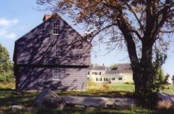
Hamilton House (1 and many other chapters): This
colonial mansion was actually built in 1785-88, after the war,
and restored during Jewett's lifetime. It overlooks the Salmon
Falls River in the southwestern part of South Berwick, once
known as the Lower Landing in Old Fields. There were wharfs,
stores, and warehouses at the Hamilton House landing site in the
1770s. Today the house and grounds are maintained by the Society
for the Preservation of New England Antiquities (SPNEA,
http://www.spnea.org/visit/homes/hamilton.htm.) and open to the
public during part of the year.
Paula Blanchard in Sarah Orne
Jewett suggests that Jewett may not have known the date of
the house's construction, though by the time she completed The
Tory Lover, she had helped to arrange for Emily Tyson and
her step-daughter, Elise, to purchase and restore the property
(See Alan Emmet, So Fine a Prospect: Historic New England
Gardens and the Society for the Preservation of New
England Antiquities guidebook, Hamilton House: a
Quintessential Colonial Revival Summer House in South Berwick,
Maine. In "River Driftwood" (1881), Jewett imagines John
Paul Jones visiting the house (342).
Various sources affirm that David
Moore's mansion, which occupied the site before Hamilton House,
was equally impressive, but that it burned between 1777 and
1783. The "gossipy" Goodwin Diary by Mrs. Ichabod Goodwin
(Sophia Elizabeth Hayes) from 1885 (Old Berwick Historical
Society) reports this as heard from Mrs. Raynes, July 31, 1884,
"On the place where the 'Hamilton House' now stands was a house
built and occupied by David More, which was burned, there was
also another large house built by Wm. Rogers ... nephew of Mrs.
More. Both of these houses were finer than the Hamilton House."
She goes on to report that the Rogers house was eventually moved
without damage to Portsmouth by gundalow. Even if John Paul
Jones did not visit Hamilton house itself, he could well have
visited a similar house at the same site. However, I have found
no documentary evidence that he traveled this far up-river from
Portsmouth, where he oversaw the completion of the Ranger.
The following in Cross-Grained
& Wily Waters, edited by W. J. Bolster (2002) draws
upon Marie Donahue in "Hamilton House on the Piscataqua," Down
East (1975): "During the American Revolution, Jonathan
Hamilton of South Berwick went privateering and amassed a
fortune. With peace he purchased thirty acres of land along the
eastern shore of the Salmon Falls River from Woodbury Langdon.
There, on a high bluff, Hamilton built a Georgian-style mansion
in 1785 that, he boasted, would be a 'finer house than Tilly
Haggens's'...." (178).
In the opening chapters, Jewett refers
repeatedly to the sound of a nearby falls, giving it
significance as a voice of Nature that speaks to Mary and Roger
of things that seem more serious than the gay party that opens
the novel. At that time, the nearest falls of any size would
have been where the Great Works River flows into the Salmon
Falls River; today this is dammed to form Leighs Mill Pond.
In contemporary Berwick, falls are
difficult to hear in the busy village, except perhaps at the
Upper Landing, but in earlier days, it was apparently different.
For example, this is a letter of June 20, 1900 to Mrs. Henry
Parkman from The Letters of Sarah Wyman Whitman (pp.
126-7): "All the stars are shining in this quiet town and peace
lies like a mantle over the hill. The rivers which gird in South
Berwick have seven falls within a mile, and a sound like that of
some mysterious sea comes on the air; and after you know, you
always, a little, hear it, and there are many things here which
give a sort of mystic quality to this old simple New England
village."
In Chapter 28, Peggy at Hamilton House
looks up the fields to a row of elms at General Goodwin's house
and watches traffic on the Portsmouth Road. See General Goodwin
on the list of People. The Portsmouth road is now known as
Oldfields Road.
(Research assistance: Wendy Pirsig).
Hampton Roads (4): A channel in southeast
Virginia between the mouth of the James River and Chesapeake
Bay. Though Jewett follows Augustus Buell in having J. P. Jones
meet Kersaint at this location, there is no evidence this
meeting ever took place.
[ Top of Page ]
Irish Sea (12,23,30): Between England and Ireland.
Island of Guernsey (41): One of the British Channel Islands, at the west end of the Channel, south of Bournemouth in England.
Isles of Shoals (7 and other chapters): Off the coast of
New Hampshire, near Portsmouth, these islands are divided
between Maine and New Hampshire. See Williamson for a
description.
Kendal (27): Between Carlisle and Liverpool on the west coast of England.
Kittery (6 and other chapters): A coastal Maine town just across the Piscataqua River from Portsmouth, N.H.
Kittery Point (7): East of Kittery, across the
mouth of the Piscataqua from New Castle. In Kittery Point stands
"Sir William Pepperrell's stately gambrel-roofed house."
The William Pepperrell home, built in 1682, is an imposing house
on Pepperrell Cove. Piscataqua Pioneers (2000) says,
"The Pepperell Mansion should not be confused with the Lady
Pepperell Mansion ... which was built by Lady Mary Pepperell in
1760 aft. the death of her husband, Sir William Pepperell"
(337). Sir William, hero of the capture of Louisburg during King
George's War in 1745, was the son of Colonel William Pepperell,
builder of the Pepperell Mansion. See Cross-Grained and Wily
Waters (2002), pp. 190-92.
[ Top of Page ]
the Lake (9): Mrs. Wallingford says men are coming down
from the Lake, which requires that she fill in for her absent
son in managing the estate. What lake this is is not clear,
though local historians speculate that Lake Winnepesaukee in New
Hampshire is the most likely location, noting that most nearer
bodies of water were called ponds, and that the more northerly
Maine lakes were not important sources of lumber for the
Piscataqua mills and ship-building in the 18th Century.
For example, Robert A. Whitehouse and
Cathleen C. Beaudoin" in Port of Dover: Two Centuries of
Shipping on the Cochecho say: "In 1824, a local [Dover]
group was formed to petition the State Legislature for two major
[Cochecho] River improvements: first the digging of a canal from
Dover to Lake Winnepesaukee so that trade routes could be
facilitated to the north country,...The prohibitive $700,000
estimated cost of such a canal led quickly to the demise of that
idea..." (17).
(Research assistance: Paul Colburn,
Brad Fletcher, and Wendy Pirsig).
Langdon's Island (12): According to The Diary of
Ezra Green, the Ranger "was built 1777, on
Langdon's Island, Portsmouth Harbor, by order of Congress, under
the direction of Colonel James Hackett." Jewett presents the
same basic information. John Langdon was a governor of New
Hampshire and the first president of the United States Senate.
This island's name proves somewhat
problematic in the novel, however. In Ch. 29, Madam Wallingford
refers to Badger's Island as the embarkation point for
the Golden Dolphin, and according to New Hampshire: A Guide
to the Granite State, the Ranger was built on
Badger Island (236). In fact, Langdon's and Badger are the same
island.
Williamson in The History of the
State of Maine lists the following Islands in the
Piscataqua river as one enters Portsmouth from the north: "On
the N. and E. side of the channel, in proceeding to the sea, are
Rising Castle, Furnall's or Navy, Seavey's, Bager's
Trefethin's, and Clark's Islands, all of which are
small except Seavey's, which lies opposite Spruce creek and may
be 3-4ths of a mile across either way; and Furnal's, or NAVY
ISLAND of 58 acres, which has been purchased by the United
States ... for a ship-yard, in which several war ships have been
already built" (v. 1, Introduction). In New Hampshire: A
Guide to the Granite State by the Federal Writer's Project
(1938), Badger's Island is identified as the site of "the
earliest shipbuilding in Portsmouth" (244).
It appears that during the
Revolutionary War, the island was called Langdon's Island, the
location of Langdon's shipyards. The most illustrious of William
and James Hackett's apprentices was William Badger (d. 1829),
who apparently married into the Rice family (see Rice's Ferry)
and eventually built ships at the Langdon Island shipyards. Ray
Brighton in Port of Portsmouth Ships and the Cotton Trade
(1986) suggests that the island was renamed for William Badger
(146). In Piscataqua Pioneers, Sylvia Getchell says the
island was originally Wither's Island, then Berry and Langdon,
before becoming Badger (11).
Today, one finds Badger Island at the
eastern end of the Memorial Bridge connecting Portsmouth and
Kittery; the island is bisected by Route 1. It remains the site
of a boatyard, though now for yachts and lobster boats instead
of ocean ships.
(Research Assistance: Wendy Pirsig)
Lebanon (8): A town in Maine on the Salmon Falls River, northwest of Berwick. James Sullivan says this town was originally Tow-woh (264). See also Williamson (v. 2, ch. 6). As Haggens says in Chapter 8, the town's name is in the process of changing from Tow-wow in the 1770s. Now there are several towns in the area, with Lebanon as part of their name. Colonel Hamilton's lumber interests in this area take him about 10 miles north from South Berwick.
Leith (25): The old port of Leith in Scotland has been absorbed into Edinburgh.
Lexington, Massachusetts: See Concord, above.
Little Harbor: See Portsmouth, N.H.
London (2 and many other chapters): The capital of
England.
Covent Garden (30): Now called
the Royal Opera House, this theater in London was opened on Bow
Street in 1732. The area of Covent Garden was originally a
convent vegetable garden, and in 1632 was designed as a garden
by Inigo Jones. (Source: Encarta Encyclopedia).
Long Island (2,9): The island east of New York City, where several important battles of the American Revolution were fought, notably the Battle of Long Island, in August 1776.
Louisburg (17,34): The siege of Louisbourg took place
during King George's War, one of several clashes between the
English and the French 18th Century. The Grolier Multimedia
Encyclopedia says: "New England's relative security ended
in 1744 when France entered the war as an ally of Spain in what
was to become known as King George's War. After their loss of
Nova Scotia in 1713, the French had constructed the large
fortress of Louisbourg on Cape Breton Island at the southern
entrance to the Gulf of Saint Lawrence. From Louisbourg, French
sea raiders could prey upon New England shipping. In 1745, Gov.
William Shirley of Massachusetts decided to capture Louisbourg;
he appointed William Pepperrell of Maine to command a New
England army in that venture. Pepperrell also gained the
invaluable assistance of a squadron from the Royal Navy.
Cooperation between these ships and Pepperrell's army of
relatively inexperienced New Englanders resulted in the
surrender of Louisbourg in June 1745 after a 7-week siege."
Jewett discusses Pepperrell and some of the history of this
siege in "The Old Town of Berwick."
Note: During the 18th-century
English
and French conflicts, the French fortress at Louisburg was
captured twice, once in 1745 and again in 1758. Tilly Haggens's
military experience, for example, includes participating in the
1757-8 expedition during the Seven Years War, also called the
French and Indian War.
Lower Landing: Location of the Hamilton House in South
Berwick, ME. See Berwick above.
[ Top of Page ]
Madam's Cove (10): Everett Stackpole in "South Berwick: The First Permanent Settlement in Maine" locates Madam's Cove on the west side of the Salmon Falls River between the mouth of the Great Works River and Hamilton House. (See also, Thompson 134 and Catalfo 257). Stackpole adds in "Sligo and Vicinity" that deep water in this cove was called "Hobbs' Hole" and that Thomas Wallingford's house stood "about two or three rods from the river and near a wading place close to the foot of Little John's Falls. After Wallingford's death, in 1771, his widow lived here many years and the cove in the river near by took the name of 'Madam's Cove'" (31). See Berwick map. (Research assistance: Wendy Pirsig).
Madeira (15): The Madeira islands are an autonomous region of Portugal, about 700 miles to the southwest. One important export is wine.
Malaga (15): A city and seaport on the Mediterranean coast of southern Spain.
The Mill Prison (27,31 and other chapters): [ Photographs & Illustration ]
The infamous Mill Prison was used mainly to imprison captives
from privateers and Navy craft during the American Revolution
and the War of 1812. During the later war, the prison could hold
3000 prisoners. It was a dangerous place, though, with poor
sanitation and generally unhealthful conditions. During the
Revolution, escape attempts were frequent and fairly successful.
Graham Frater's examination of Plymouth Records indicate
that between 1777 and 1779, 734 Americans were held here. Other
sources indicate that about 1500 Americans spent time here
during the full course of the Revolution, until 1783.
Frater writes:
The account of the condition of the prisoners is so detailed and convincing that I wonder if Jewett might be transposing oral evidence from her grandfather's accounts of his own imprisonment by the British in the War of 1812. Paula Blanchard (Sarah Orne Jewett, 1994, p.8) records that Theodore Furber Jewett was held on the infamous Dartmoor prison ship at Bristol. In addition to Plymouth's Mill Prison, American prisoners were held in Bristol (in the Stapleton Prison, now Blackberry Hill Hospital, source: John Penny), and in Dartmoor Prison in Devon (still in existence). John Frost's Sarah Orne Jewett, (1960, p.13) records that 'During the War of 1812, [T. F. Jewett's] brig was seized, and he was placed in Dartmoor Prison in England, and forwarded to the prison at St George's, Bermuda, before he could be exchanged with a prisoner of equal rank.' Grandfather Jewett might have been held first in Bristol, forwarded to Dartmoor, and thence to Bermuda.
Dartmoor Prison is located at Princetown in Devon (Some 16 miles or so from Plymouth's crowded Mill Prison); Jan Wood, Archivist of the Devon Records Office writes: "Princetown St Michael and All Angels Parish Church [now deconsecrated] is a listed Grade II building, now under the care of The Churches Conservation Trust. It was built in 1814 by the prison inmates. The French Prisoners-of-War started the project by digging the foundations and erecting the stone walls. Later, it was completed by the American prisoners, who built the roof and fitted all the internal woodwork and fixtures. The prisoners were paid 6d (2 1/2 new pence) a day for their labours, and the magnificent east window of the church is a memorial to the 1200 French and 200 Americans who died whilst at the prison." A window commemorating the American prisoners of Dartmoor was dedicated in 1910 by the Daughters of 1812 Society.
See also: www.devon.gov.uk/dro/dartmoorprisonframe.htmlAnd see:
Francis Abell, Prisoners of War in Britain, 1756 to 1815.
Charles Herber, A Relic of the Revolution http://www.americanrevolution.org/relic.html
Nantes (2, 15 and other chapters): A city of western France at the head of the estuary of the Loire River at the juncture of the Erdre and the Sèvre rivers 35 miles from the sea and southwest of Paris, which has remained as a center of commerce since the Roman invasion up until present. (Research: Travis Feltman; Source: Encyclopedia Britannica Online)
Newbury and Newburyport (31): Both of these towns are in northern Massachusetts. Newburyport is at the mouth of the Merrimac River; Newbury is south of Newburyport, on the Parker River.
Newcastle (7 and other chapters): Now New Castle, a town eastward across the harbor from Portsmouth, N.H., on an island previously known as Great Island. New Hampshire: A Guide to the Granite State says, "... in the years preceding the Revolution it was alive with intrigue and excitement. Here lived the Governor and his officials; here were held the councils and courts of law. The prison for the whole province was at New Castle.... Its taverns were crowded with gay, philandering soldiers of fortune, and its prisons were full of traitors and ministers in danger of the Tower of London, or of the gallows" (266). Fort William and Mary (later Fort Constitution), located here, was the site of an early American success when in 1774, the Sons of Liberty and local patriots under the leadership of the future General, John Sullivan and John Langdon captured the fort and removed a large store of gunpowder that was then used by American forces at Bunker Hill (New Hampshire 266-7).
Newcastle in Northumberland (24): an English port on the northeast coast known for shipping coal.
Newington (7): A town just northwest of Portsmouth, NH.
Northwood (7): Northwood is west of Dover, NH. The Northwood hill visible as Roger sails out of Portsmouth is likely to be Saddleback Mountain. This hill would, in fact, be very difficult to see from Portsmouth harbor.
Notre Dame: See Paris.
[ Top of Page ]
Old Fields (28,31): Everett S. Stackpole in "South Berwick: The First Permanent Settlement in Maine," locates Old Fields at the southern end of the current village of South Berwick. He says this was originally the location of the Spencer Garrison, built before 1675. See Berwick.
Old North Church: See Portsmouth.
Old Passage Inn: see Severn below.
Lorient/L'Orient (23): A town in western France, west-southwest of Paris, in Brittany (Bretagne) on the right bank of the Scorff River at the juncture of the Blavet River on the Bay of Biscay. The fishing port remains one of the most important in France, and its reputation as a center of commerce with the eastern world is the source of its name. (Research: Travis Feltman; Source: Encyclopedia Britannica Online)
Orléans (21): A city of north central France on the right bank of the Loire, 77 miles southwest of Paris; a center of communication and transportation between Paris and the Loire basin. Research: Travis Feltman; Source: Encyclopedia Britannica 11th Edition)
mountains of Ossipee (16,32): Now known as the White
Mountains in New Hampshire, northeast of South Berwick.
[ Top of Page ]
Paris: Capital of France (2 and many other chapters).
Research on the following locations in
Paris is by Travis Feltman.
The Basilica of Saint Denis (17): A cemetery located north of the city of Paris where the remains of a martyred bishop, Saint Denis, were put to rest along with all but three of the kings of France; the kings were dug up during the French Revolution and tossed into a common grave with lime to ensure that the bodies would fully decay.
Bastille (22): A medieval fortress on the east side of Paris. A prison in the 17th and 18th centuries, it was emptied at the beginning of the French Revolution in 1789. (Source: Encyclopedia Britannica Online)
Louvre (22): In the 17th-century, this royal palace was converted into an art museum; it is now the national art museum of France.
Notre Dame (17,22): A Gothic cathedral in Paris, accentuated by two towers. This popular tourist attraction stands on an island in Seine River, known as Île de la Cité. (Source:Encyclopedia Britannica Online)
Place du Palais Royal/pleasant courts (22): A town square along the Avenue de l'Opéra in Paris. Opposite the middle of the Louvre, it leads to the palace of Cardinal de Richelieu ,occupied by several kings and accentuated with magnificent gardens, galleries, and a theatre. (Source: Encyclopedia Britannica Online)
Passy (15,22): Now characterized as an expensive residential and commercial district on the right bank of the Seine near the Champs-Élysées. The American Commissioners to France during the American Revolution resided in this area.
Tour St. Jacques/St. Jacques bell tower (17,22): The remnant of an old church standing on the Rue de Rivoli in Paris at the head of the Rue St. Jacques, an ancient Roman road running south. It was a source of pilgrimage during the 10th century, for those traveling to the tomb of the apostle, St. Jacques (James) in Spain. The church was demolished in 1797. (Source: Encyclopedia Britannica Online)
Passy: See Paris.
Pine Hill (3,9,16): Named as the location of Master Sullivan's school, this Pine Hill is just north of the village of Berwick, about seven miles from Hamilton House. A fort built on this hill was called Hamilton's garrison; Williamson reports it was still standing in 1750 (v. 2, ch. 3). The John Sullivan farm was located here, and this was the original burying place of John and Margery Sullivan. See John Sullivan in "People."
Piscataqua (2 and other chapters): (See Berwick map and Portsmouth map) This name refers to the region of southern Maine and eastern New Hampshire through which the Salmon Falls and Piscataqua Rivers flow. Though names have varied in the past, on modern maps, the Salmon Falls River ends when it meets the Cocheco east of Dover. From this meeting to Portsmouth, the river is called Piscataqua. Different interpretations of the word include: "right angles" (Williamson) and "dividing point of waters" (New Hampshire: A Guide to the Granite State).
It is important to keep in mind that
up to Salmon Falls, the Piscataqua/Salmon Falls River is tidal.
Even at the tide-head, the variation between low tide and high
tide is several feet, enough to make it possible to bring large
sailing ships to the Lower Landing at high tide. This fact also
contributes to dangers on the rivers as the water level changes
quickly when the tide flows in and out of the valley; and in
shallower areas, parts of the river became rapids as the tide
flowed out, before some rocky areas were blasted out in the 19th
century. In this area tidal currents flow as fast as seven miles
an hour and are among the swiftest in the United States, posing
a great challenge to sail-powered ships, even at Langdon's
Island, near the mouth of the Piscataqua, from which the Ranger
sails. References in the novel to coordinating river travel with
the tides reflect this situation,
Another important aspect of the tidal
river for this novel is that there were few bridges on the river
in the 18th Century. Mary takes a boat to visit Madam
Wallingford on the New Hampshire side; there is a ferry between
Kittery and Portsmouth. At low tide, however, there were at
least two "wading places" in the South Berwick area. It seems
clear these are used regularly in the novel to cross the river
at South Berwick, for example, on November 1, 1777, when
Jonathan Hamilton rides to his northern property, crosses the
river at Great Falls on his return, intending to visit Madam
Wallingford, and somehow gets his horse back across the river to
his home at Hamilton House in the evening. Presumably, he knew
he'd be returning at low tide, when he could easily wade his
horse across the river.
Points that are named along the Salmon Falls and Piscataqua Rivers.
These appear in their rough order along the rivers. Most of
these locations were determined by looking at maps and local
records at the Old Berwick Historical Society, with the
essential assistance of Tim Benoit, Brad Fletcher, Norma Keim,
and Wendy Pirsig. An essential source is Mary P. Thompson, Landmarks
in Ancient Dover (1965).
Some of these identifications are
uncertain, being mainly local names mentioned once or twice in
documents that indicate their locations. I have tried to
describe them so they may be found on contemporary maps, such as
those in DeLorme's state atlases. (See maps.)
Madam's Cove (10): Upriver and on the NH side, just above Hamilton House. See above for details.
Hamilton House and wharfs: see Hamilton House above.
Stiles's / Style's Cove (6): Now known as St. Alban's Cove, about 1/2 mile downstream from Hamilton House on the NH side. Style's (now St. Alban's or sometimes Sligo) Brook empties into the cove according to Catalfo (265-6).
Pine Point (8): This point on the NH side forms the southern end of Stiles's (St. Alban's) Cove (Thompson 205). Hamilton reports in Ch. 8 that he watched his brig sail from his wharf down the river to this point. Mary Thompson locates another Pine Point in Newington, but this would be too far away for Hamilton to see his brig.
Devil's Reach (6): No records
of this name have been found, but the other locations Jewett
mentions suggest strongly that this is the straight portion of
the Salmon Falls River from St. Alban's (Stiles's) Cove to what
is now Eliot Bridge (Gulf Road / Rte.101).
Wendy Pirsig has speculated about
applying this name to this part of the river:
"The term reach typically
refers to a long stretch of straight sailing, but it also has
another sense. In sailing, reach also refers to the
relationship between the boat, the sail and the wind. Usually
everybody loves a reach, because the wind is coming across the
beam of the boat, about 90 degrees to your forward direction; a
close reach is when you are pointing a bit more than
that, into the wind, and it's a broad reach when you
have a bit of the wind behind you. The boat sails efficiently
that way, without a lot of crew work.
"Because the Salmon Falls is a
north-south river and prevailing winds are westerly, the river
men sailed on a reach for much of the upstream journey, much
more than on an east-west river; whether they were sailing a
gundalow up to Berwick or sailing a newly built ship down from
Hobbs' Hole to Portsmouth, they would be on a reach in a
westerly wind. However, if you know rivers, you also know that
their narrow shape tends to distort land breezes, by channeling
them along the direction of the river, as though the banks and
trees along the water grabbed the air and pushed it down a
chute.
"I noticed when kayaking this stretch
we think is Devil's Reach that even in a very light the breeze
the wind would shift around whimsically, and I had to push
against much of the way upstream, at least till I reached
Hamilton House.
"What likely happened frequently in the
old days was that a crew sailing home on a nice reach would
round the bend at what is now Eliot Bridge and bring Hamilton
House into view, and then the wind would 'diabolically' turn
against them. The Lower Landing would be a mile and a half ahead
of them at that point, but it would look so close, and their
suppers would be waiting, and maybe the sun sinking, and -- most
importantly -- a tide that had been favoring them would be
changing against them, meaning the opposing currents could slow
them further, and they'd be so late they wouldn't clear
Littlejohn's falls (low water below the mouth of the Great
Works) at all that night and instead of reaching Quamphegan
(Upper) Landing, they would have to spend the night waiting out
the tide at the Hamilton House or Madam's Cove.
"So, I can imagine them cussing about
Devil's Reach all the way along that part of the river.
"Another point to consider is that this
kind of sailing -- with changing currents and fluky wind -- is
so difficult that no one is capable of it any more. You will
never see anyone sailing any distance on the Piscataqua/Salmon
Falls now, not even in a modern rig that sails more efficiently
than the old gundalows and ships ever did. Today, whenever the
local Piscataqua gundalow replica moves on the river, or tall
ships visit, heaven forbid that anybody puts a sail up and
threaten the safety of everything in sight. The gundalow people
charter a tugboat to motor it safely from place to place. The
skills the old river people have are just gone along with the
circumstances that forced them to move by wind on this river."
Sligo Point beyond the Gulf Road (13): This is the area Dr. Green reports visiting his eccentric patient, telling a story he and Dickson share. Almost certainly this is on the NH side, and may be the curve in the Salmon Falls River just before the Eliot Bridge. Green indicates that he takes Gulf Road from Dover to reach Sligo Point; today Gulf Road leads to Eliot Bridge (Rte 101). However, we have no authority for this location, and some local scholars believe Sligo Point was below Eliot Bridge, perhaps after High Point, being the name for the triangle of land at the confluence of the Salmon Falls and Dover (now Cocheco) Rivers.
High Point (6): Mary Thompson says High Point is "the first point on the Rollinsford (NH) shore ... below the Eliot Bridge (99). In "River Driftwood" Jewett says High Point is one of the limits of her own boat navigation on the river.
old Hodgdon Farm and Hodgdon's Landing (6): The 1872 York County, Maine Atlas shows that two Hodgdons owned land on the Maine side, where Quamphegan Brook flows into the Salmon Falls River just past the Eliot Bridge. This might well be the area to which Jewett refers. Thompson says there was a Hodgdon's Point just down river from Bloody Point, which is across from what is now Dover Point. This name appears in documents as late as 1770 (104).
Rice's Ferry (28): This refers
to the ferry between Market Street in Portsmouth, NH and Kittery
in Maine, across the Piscataqua River. Until 1822, there were no
bridges between Portsmouth and the Maine side (Brighton, They
Came to Fish v. 2, 141). The following information
indicates that the ferry would have been called Rice's Ferry in
the 1770's.
According to Nathaniel Adams in Annals
of Portsmouth, the city obtained the rights to the ferry
in 1722 and began to lease these to individuals (142). In 1822,
when the first Portsmouth bridge was opened to traffic, the city
compensated the ferry operator, Alexander Rice, for his loss of
the ferry (383-4). John E. Frosts's Maine Probate Abstracts
offers this account of the ferry in an entry on Alexander Rice
(1760-1836): "Until the Piscataqua was bridged in 1822, Rice's
Ferry was the principal point of entrance to and departure from
Maine. To this lucrative monopoly at the end of Ferry Lane (now
Rice Avenue) the Rices added a commodious tavern at the Maine
end of the crossing. Alexander inherited from his father the
ferry and tavern and further increased his comfortable income by
bridge construction ...." (v. 2, p. 235).
In Witch Trot Land by Anne
Mountford and Katherine Marshall, 1937, appears a picture of the
Rice Tavern: "The Old Rice Tavern stands where Thos. Whithers'
ferry used to dock, daughter Mary later marrying Thos. Rice. The
ferry finally quit for the new (now old) wooden toll bridge up
river, at present being used by the railroad, hence the Inn was
no longer needed" (6).
Piscataqua Pioneers tells
about Thomas Trafton, ferryman and innholder from about 1688 to
1700, who died by 1707. He lived near the Rice's Bridge site,
where he owned the ferry. His son Zacheus, a blacksmith,
succeeded his father at the ferry, married Annabel Allen first,
then Mary Bickford Walker in 1748 (426-7).
Also of interest may be that Jonathan
Hamilton was the partner of Samuel Rice (d. 1791, father of
Alexander) in the ownership of two trading vessels operating
after 1785.
Whether this Rice family is related to
Sarah Orne Jewett's family through her grandfather Theodore's
third marriage has not been determined. Further information is
welcome.
Research assistance: Mary Ellen
Robertson
Plaisted's Hill (8): Site of the Plaisted Garrison, an early colonial farm, where several of the Plaisted men, including Roger Plaisted and his son, also Roger, were killed in a memorable fight with Indians. (The Old Town of Berwick).
Plymouth (14 and other chapters): On the south coast of England, this is the location of the Mill Prison, where American naval prisoners were kept during the Revolution.
Plymouth Hoe (37): In archaic usage, a hoe is a promontory or point of land. The Oxford English Dictionary points out that the word is preserved only in a few place names, such as the hoe at Plymouth, where the point extends into the sea.
Mill Prison: See above.
Plymouth (16): in Massachusetts; site of the first permanent English colony at Plymouth Plantation, characterized by Puritan Protestantism.
Convent of Port Royal (17): The Convent of Port-Royal-des-Champs was a center of Jansenism in France. It was closed and razed in 1709 by order of King Louis XIV.
Portsmouth (1 and many other chapters): (See Portsmouth
map) This New Hampshire port town in Rockingham County is at the
mouth of the Piscataqua River. Before the Revolution, Portsmouth
was the capital of the New Hampshire province. Made prosperous
by fishing, ship-building, and West India trade, in the 18th
Century, Portsmouth was one of the main ports north of Boston.
(Main source: New Hampshire: A Guide to the Granite State).
Jewett saw Portsmouth as a secular colony
that reflected the interests of the English aristocracy, in
contrast to Plymouth, MA, a settled that emphasized otherworldly
goals and reflected the interests of religious dissenters from
the English establishment.
Portsmouth locations mentioned in The Tory Lover
Earl of Halifax Tavern (2): General Goodwin says about Roger: "I am afraid that we can have no doubt now of the young man's sympathy with our oppressors .... I hear that he has been seen within a week coming out of the Earl of Halifax tavern
New Hampshire: A Guide to the
Granite State says: "The Pitt Tavern ... cor.
Court and Atkinson Sts... was originally called the 'Earl of
Halifax Tavern,' and during the early part of the Revolution was
a meeting-place for the Tories. When the Patriots attacked it in
1777, the penitent host immediately changed its name to the
William Pitt Tavern, in honor of the great friend of the
Colonies.... Among those entertained at this tavern were John
Hancock, Elbridge Gerry, General Knox, Lafayette, the three sons
of the Duke of Orléans, Louis Philippe and his two brothers, and
in 1789 George Washington." This tavern is now a part of the
Strawbery Banke historical museum.
However, the date of the name change is
problematic. Drawing upon Brewster's Rambles About
Portsmouth, Raymond Brighton, in They Came to Fish
(1973), offers much colorful history of John Stavers's
management of the Earl of Halifax and of the incidents that led
Stavers to change the name, but he does not give a precise date.
The Strawbery Banke Museum says the riot took place on January
29, 1777, but suggests that the name change did not take place
until after May of that year. In any case, it was not safe for
known Tories to frequent the tavern after January 1777, and at
the end of October 1777, Roger would not have been seen within
the last week at the Earl of Halifax, unless General Goodwin
(accidentally?) calls it by its old name.
(Research Assistance: Don Fancy and
Richard Winslow)
Little Harbor (7): The
southern shore of the mouth of the Piscataqua River. On the
harbor stood the Benning Wentworth Mansion (7), begun in
1695 and added to until it became a "rambling, huge old
mansion," with a council chamber, billiard room, and 30 other
rooms, including card rooms. New Hampshire: A Guide to the
Granite State says that Royal Governor (1741-1767) Benning
Wentworth "held court in high-spirited style, keeping up the
aristocratic tradition of beeswing port and high play at cards"
(265). The guide also points out that Henry Wadsworth
Longfellow's poem, "Lady Wentworth," describes the mansion, and
that Jewett's acquaintance, historian Francis Parkman, spent his
summers in the mansion. From 1886 to 1945, Boston arts
enthusiast J. Templeman Coolidge turned the mansion into the
center of a summer arts colony at Little Harbor (Crossed
Grained and Wily Waters, 64), and Jewett probably was
aware of this. The house today is known as the
Wentworth-Coolidge Mansion and is open to the public during the
summer.
(Research Assistance: Wendy Pirsig)
old North Church (7): The old North Church at Pleasant and Congress Streets was built in 1712, with a bell added in 1764. The church was replaced in 1854.
Portsmouth Parade (2 and other chapters): This open area in the center of old Portsmouth was used for military exercises and town gatherings. Brighton says that when the State House was built in about 1758, it included a balcony that faced onto the Parade across from North Church and from which public documents were read to gathered citizens (They Came to Fish v. 2, 24). This space remains in Market Square, where it is a local transportation hub and a place to gather for shopping, eating, and socializing.
Queen's Chapel (10): According to New Hampshire: A Guide to the Granite State, Queen's chapel was built in 1732 "in honor of Queen Caroline, who furnished books for the pulpit, two mahogany chairs and the plate, all bearing the royal arms" (238-9). The chapel stood on Strawberry Bank, but was replaced in 1807 by St. John's Church, on Chapel St.
Spring Market (7): Located on Bow Street, this was called Spring Market because there was a spring at the corner of Bow and Ceres Streets. Today, the spring can be seen downstairs in the bar of the Dolphin Striker Restaurant. (Research Assistance: Wendy Pirsig and Don Fancy)
St. John's steeple (7): Jewett would seem to be in error in Chapter 7 about the ringing of the bells in St. John's steeple when the Ranger sails out of Portsmouth. According to New Hampshire: A Guide to the Granite State, St. John's church was not built until 1807. Its bell, however, is noteworthy, "taken from the French at the siege of Louisburg in 1745" (238-9).
Portsmouth Parade: See Portsmouth.
Pound Hill: See Berwick above.
Quiberon (18 and other chapters): a peninsula and town
on the southern Breton coast. See Breton coast.
[ Top of Page ]
Rennes (21): A city in western France in Brittany (Bretagne), located at the confluence of the Ille and Vilaine rivers from which canals branch throughout the city. (Research: Travis Feltman; Source: Encyclopedia Britannica Online)
Rice's Ferry: See Piscataqua above.
Rockingham towns (2): Exeter and Portsmouth are in Rockingham County, in the southern part of the New Hampshire.
Rocky Hills (9): The Rocky Hills stretch from south to east of South Berwick. Jewett describes a ride into this area in her story, "An October Ride" in Country By-ways.
Roscoff (39, 41, 44): A French fishing port on the north
Breton coast, northeast of Brest.
[ Top of Page ]
St. Augustine's church: See Bristol.
St. Bees Head (24): Southwest of Whitehaven, this is a projection of land into the Irish Sea.
St. John's church: See Portsmouth.
St. Mary Radcliffe: See Bristol.
St. Nazaire: See Breton coast.
Saco (2 and other chapters): A Maine town near the coast on the Saco River, about 10 miles south of Portland. James Sullivan is said in Chapter 3 to live in the village "at the falls of the Saco," which would be either Saco or Biddeford.
Salem (4 and other chapters): In Massachusetts, north of Boston, famous for the Salem Witch Trials of 1692.
Salmon Falls (12 and other chapters): Between Rollinsford, NH and South Berwick, ME on the Salmon Falls River. The name also was given to Rollinsford's 19th century textile mills at the falls, and for a century denoted the mill village there. (Research Assistance: Wendy Pirsig)
the Severn, above Avon mouth (41-43): Research on the
Severn and Old Passage Inn is by Graham Frater.
[ Photographs ]
The Severn is the principal river that flows
into the Bristol Channel. It is tidal for a good deal of its
length, the Severn bore being a particularly strong seasonal
tide with a fearsome reputation. Avonmouth is a town west of
Bristol, where the Upper Avon flows into the Severn.
Old Passage Inn (42): The
Old Passage, was at Aust some 14-15 miles north of Bristol city
centre as measured on a modern roadmap. Just as Jewett suggests,
there was a ferry that crossed the river to Beachley in
Gloucestershire. After the crossing, travellers would have gone
on to Chepstow (Wales), and thence perhaps to crossings for
Ireland. A dramatic modern suspension bridge close by replaced
the ferry in 1966.
Walking the ground today, Jewett's
descriptions seem strikingly accurate. A road does run up to the
site of the Old Passage Inn from the Bristol direction, much as
described, and it does lie below the remains of a dyke, which
also runs up to the house. The former inn was indeed on a
headland, also as described, and was of gray stone (though this
is now covered with render). The land is flat along the
Severn, and the dyke would have been a flood protection just as
the text suggests. However, the dyke and the surrounding
landscape, at least as seen today, are a good deal less
dramatically gothic than the Woodbury
illustration in The Tory Lover.
The Old Passage Inn survives as a much
expanded private house, currently owned by Mr and Mrs T. Ross,
who kindly permitted a visit and photographs. The inn did indeed
have a number of outhouses and stables to support a constant
stream of ferry passengers, as shown in a print from the 1790s.
From Wales and Ireland to English markets,
the Old Passage seems to have been a favourite route for drovers
who were such regulars at the Old Passage Inn that the present
owners can still point out the 'Irish room' at the top of the
house, where drovers were customarily lodged. Wallingford's
arrival at the inn disguised as a drover travelling from
Chippenham, a market town some 30 miles to the south east of
Bristol (as measured on a modern road map), is, therefore,
entirely in keeping with the character of the location. It was
common for both Irish and Welsh cattle to be driven across
country to English markets.
Though no evidence has been found to show
that Jewett visited the part of England, her descriptions of the
inn, the surrounding area, and the route from Bristol suggest
that she was familiar with this setting.
Skibbereen (17): Near the southern tip of Ireland, south of Bantry.
Sligo Point ... Gulf Road: See Piscataqua above.
Slindon (36): Lord Newburgh's wife, Barbara Kempe, received the Slindon estate as a wedding present from her father. See Dilston Hall above.
Smock Alley Theatre: See Dublin.
Somersworth (2 and other chapters): A town in New
Hampshire, northward from Dover, today, it is just across the
Salmon Falls River from Berwick, Maine. New Hampshire: A
Guide to the Granite State says, "Originally a part of
Dover, Somersworth was set off as a parish in 1729 and became a
separate town in 1754. Its name was first spelled Summersworth
and was probably derived from 'summer-town,' the name given by
the Rev. John Pike when he spent his summers preaching here.
Originally it was known as Great Falls, a name it retained until
it was incorporated as a city in 1893" (273). However, since we
are told Mrs. Wallingford lives in Somersworth, we need to
revert to 18th-century usage, when Somersworth
included what is now the village of Rollinsford, just across the
Salmon Falls from South Berwick, and the shore opposite
Hamilton House. Madam's Cove is in what is now known as
Rollinsford, but in her time was called Somersworth.
(Research Assistance: Wendy Pirsig)
[ Top of Page ]
Tow-wow: Also Tow-Woh. See Lebanon.
Upper Landing: See Berwick.
Valley Forge (16,32): George Washington's Continental Army made its winter camp at Valley Forge, Pennsylvania in 1777-8, during what is described as the darkest period in the military campaign for American independence. The army was inadequately clothed, sheltered and fed; many died of disease and exposure.
Old Vineyard: See Berwick.
Vitré (21,22): A town of northwestern France on
the left bank of the Vilaine, 24 miles east of Rennes.
(Research: Travis Feltman; Source: Encyclopedia Britannica
11th Edition)
Wentworth Mansion: See Portsmouth.
Westbury on Trym (35,41,43): Westbury is southeast of Bristol, England, in the direction of Salisbury. Graham Frater writes: "Westbury on Trym is now a dormitory village to the north of the Bristol city centre lying within the greater Bristol conurbation. The parish church remains; it is placed on a hill, from which its pretty chimes would have been widely heard."
Whitehaven (24 and other chapters): [ Photographs and Illustrations ] A port on the northwestern coast of England, across the Irish Sea from Belfast and Carrickfergus. Whitehaven was an important port across Solway Firth from Jones's birthplace, Arbigland in Scotland. It was from Whitehaven that Jones, when 13, began his apprenticeship under Mr. Younger on the Friendship in 1761 (Morison 11).
White Hills (8 and other chapters): The White Mountains, northwest of Berwick in New Hampshire.
Windsor (34): Private residence of the English royal family.
Witchtrot road (31): Witchtrot Road runs north from York
Woods Road to Emery's Bridge Road, east of South Berwick. In
"The Old Town of Berwick," Jewett says: "There is one incident
connected with the Salem witchcraft delusion which has given an
unforgetable name and association to a certain part of the
present town of South Berwick, in connection with the summoning
of the Rev. Stephen Burroughs, of Wells, to appear before the
judges in Danvers [Massachusetts]. The whole history of
Burroughs is most interesting and perplexing. He was a man of
amazing strength and a curious knowledge of woodcraft, but was
accused of cruelty and various misdeeds. An enemy of his in
Danvers, where he had formerly preached, was despatched to Wells
on the welcome errand of bringing him to justice, with the help
of two constables, - the strength and cleverness of Burroughs
being quite enough to found the charge of witchcraft upon, and
cover the desire of revenge for a private grudge. They found the
man at his parsonage; and, sure of proving his innocence, he
readily agreed to accompany them, but suggested that they should
take a shorter path than by the road they had come, -- round by
the old coast or post road through York. They pretended
afterward, or perhaps believed, that he cast a spell on them,
and led them into a gloomy forest, presently coming out on a
high, strange ridge, like a backbone to the country. As it grew
dark a great thunder-storm gathered, but Burroughs alone seemed
to know no fear, and kept on his way. The messenger and his two
constables nearly perished with fright, and believed the whole
situation to be diabolic. The horses seemed to fly, and the
lightning flashed blue and awful gleams about Burroughs, as he
rode ahead; and so things were at their worst as they hurried up
and down the steep hills of what has ever since been known as
the Witch Trot Road. Suddenly the storm ceased, as
thunder-storms will, and the moon shone out; and they found
themselves near the calm water of the river, near Quampeagan.
This was proof enough in that moment of Burroughs's evil powers,
and his fate is a matter of history. The Danvers men told the
story of their fearful ride, with great glory to themselves no
doubt, for many years; and though those who were familiar with
the country insisted that the road to the river was shorter by
half than the long way through Cape Neddick and Ogunquit, it was
easier to accept the marvellous than the reasonable."
Jewett reports this story as "oral
history," and historians have questioned some aspects of it.
Wooster's river (16): This stream flows into the Salmon
Falls River downstream from Great Falls, between South Berwick
and Berwick. It became significant in local history because of a
skirmish fought there in 1690 between local settlers and a band
of Indians, led by a Frenchman, who had staged an attack on the
Salmon Falls settlement. (See Hertel).
X/Y/Z
York (2 and other chapters): This Maine costal
town is near Berwick. The following information about the
historical York Garrison is from the Michelin Guide to New
England (1993). "In 1624 the Pilgrims established a
trading post at Agamenticus, the present-day site of York. The
small settlement that grew up around the trading post was chosen
by Sir Ferdinando Gorges, the proprietor of Maine, as the
capital of his vast New World territory. In 1641, Sir Gorges
gave the village a city charter and renamed it Gorgeana in his
honor." Gorges plans for the area failed, and the village was
reorganized as York by the Massachusetts Bay Colony in 1652. In
the 18th century, York was the provincial capital,
where terms of court were held. Old York Village is a
museum today, where one can visit several preserved sites and
buildings, including the old York jail. York Garrison,
officially known as McIntire Garrison, was built in about
1665. This photograph of the restored building was taken
in September 2002.
Terry Heller, Coe College
[ Top of Page ]